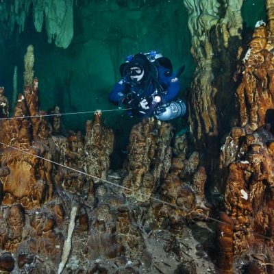
The Yucatan Peninsula is built on a vast limestone platform that hides some of the world’s longest and most beautiful flooded cave systems. At the turn of the Mesozoic and Cenozoic eras, this region of today’s Mexico lay beneath a shallow sea, forming an enormous coral reef. Over time, with the repeated rise and fall of sea levels during glacial and interglacial periods, the reef alternately emerged above the ocean surface and then disappeared below it again.
During the ice ages, massive amounts of water became locked in polar and subpolar ice sheets, causing global sea levels to drop, an effect most noticeable in the tropics.
When the ice ages ended, the ice sheets near the poles melted and sea levels rose once again, partially or completely flooding the exposed surface of the Yucatán Peninsula. During glacial periods, when the peninsula was exposed above sea level, it was subjected to rainfall that was naturally slightly acidic due to CO₂ in the atmosphere and soil.
Because limestone is layered and fractured by tectonic activity, it easily absorbs water. The acidic water dissolved the rock (corrosion) and, as it moved through the subsurface, carried particles that gradually enlarged the passages (erosion). Narrow drainage channels expanded into cave corridors, and these passages eventually interconnected into extensive cave systems.
When the water table dropped, dry passages experienced the reverse process. Groundwater rich in dissolved limestone seeped from cracks into the open air of the caves, where the minerals precipitated and formed stalactites, stalagmites, flowstone, and other karst formations. This continued until the next interglacial period, when rising sea levels lifted the water table and once again flooded the newly formed caves. When a cave floods, speleothem growth stops, but only to restart thousands of years later when the next ice age lowers sea levels again.
The most intense alternation between glacial (ice age) and interglacial periods began in the Pliocene, roughly 2.5 million years ago. Glacial periods lasted 40,000 to 100,000 years, while interglacial periods typically lasted around 20,000 years. The last major ice age ended about 10,000 years ago. At that time, sea level rose by about 120 meters (394 feet), permanently flooding the richly decorated cave systems that had developed over hundreds of thousands of years.
Today, all freshwater in the Yucatan peninsula flows through these caves. Karst regions often lack surface rivers because rainwater quickly infiltrates the ground and travels underground. The dissolution of limestone by acidic rainwater continues even now. Over time, the integrity of cave ceilings (especially above former large dry chambers) weakens. When a ceiling collapses partially or fully, it opens a vertical entrance into the underground labyrinth. In Mexico, these openings are called cenotes, derived from the Mayan word d’zonot, meaning “sacred well.”
For the ancient Maya, cenotes were the only source of drinking water and held deep mythological importance. They were considered sources of fertility and life, gateways to the underworld, and the home of the rain god Chaac, who was honored with human sacrifices.
The Yucatan Peninsula is dotted with cenotes like holes in Swiss cheese, especially along the coast between Playa del Carmen and Tulum and around Mérida. Most cenotes (and the cave systems that connect them) remain undiscovered. Those that have been found offer access to breathtaking worlds filled with spectacular formations, and diving in them is a once in a lifetime experience for divers who travel to Yucatan from all over the world.
Karst development on the Yucatan Peninsula continues even in today’s interglacial period, mainly through the slow collapse of thin cave ceilings, a process that takes hundreds to thousands of years for a cenote to form. In the state of Quintana Roo alone, which covering roughly one-third of the Yucatan Peninsula, the local speleological survey has documented over 1,000 cenotes in more than 400 independent cave systems, totaling more than 1,800 kilometers (1,120 miles) of surveyed passages.
The first discoveries, explorations, and surveys of flooded Yucatan caves began in the late 1970s, carried out by cave divers from Florida.
Every year brings new exploration attempts and expeditions, leading to newly discovered cenotes and cave systems. A cave system refers to a network of caves and their entrances (in this region, cenotes), interconnected by flooded passages. It is common for explorers to find that one cenote connects to another through a submerged corridor, merging two previously separate caves into a single, larger system. A cave system can contain dozens or even hundreds of cenotes.
The longest known cave system, Ox Bel Ha (Three Paths of Water), contains over 150 cenotes and more than 500 kilometers (310 miles) of surveyed passages. Far behind is Sac Aktun (White Cave), measuring around 380 kilometers and containing about 230 cenotes. The third longest system, K’oox Baal (Wild Thing), exceeds 100 kilometers (62 miles) and includes 57 cenotes.
For divers who invest the time and resources to complete cave diving training, acquire specialized equipment, and pursue the long and often challenging path of skill development (with a love of adventure and sound judgment), Yucatan offers unparalleled opportunities to explore untouched, pristine, and truly extraordinary environments.


